Something I’ve always found quite interesting is to look at the phases of development a city has had. How big was the city in 1900? Where developed prior to the First World War? How about between the wars? Why did development occur in those places first rather than elsewhere? How do the street patterns, building type and general feel of an area reflect the times it was built in?
Exploring this process of urban development through analysing the city is an interesting process. I’ve already talked about the oldest part, which probably dates from the 1600s, or perhaps even earlier. So that forms phase one of our city’s development, perhaps generally where things were at in around 1750 – so still a fairly small place, although pretty intensively built up.
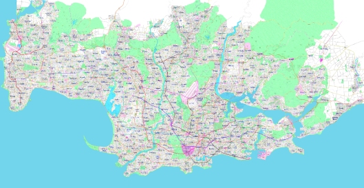
The first phase of development is the purple area in the picture above.
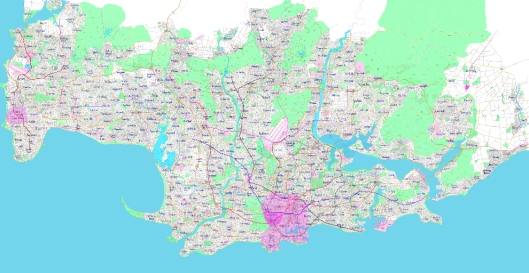
By say 1850, railways and the industrial revolution has really started to change our urban places. Typically the need for walls had stopped, plus cities were struggling to fit within those boundaries anyway. Here we also see the earliest stages of New Haven developing in the west, highlighting that its urban core also dates from a pretty early date. Our main area has grown fairly considerably and would have perhaps had a population pushing 250,000 – all pretty tightly packed in as most people needed to live within walking distance of where they worked. We also see the use of the port becoming increasingly important:
The third stage is where the city would have reached at 1900. This is a fairly arbitrary cut off date in a sense, but shows us that the second half of the 19th century continued to be a time of really rapid urban growth. This pre-1900 area forms a pretty distinctive “core” to the current metropolitan area, we see development following the rivers (for transport purposes and perhaps because industry wanted to be there too) and also following where some of the metro lines are today, telling us that these lines were probably some of the earliest, precipitating urban development around them:
The fourth phase, which is where the city would have been by the time of the Second World War, indicates a further level of quite extensive development during the first half of the 20th century. Some master-planned communities would have followed urban trends at the time, like the Garden City movement. This is perhaps most obvious in the suburb of Solaris, which I will dedicate a post to in the future. Development has also taken place along the harbour, as perhaps the rise of the automobile meant that people were no longer strongly required to live near a train station or tram line to get to work, although the extensive Metro network the city had at this point probably meant lower than average car ownership rates (sort of like New York in the USA). Population is likely to have hit a million in the early years of the 20th century, and perhaps has reached 1.5 million by World War II – indicating slower growth since that time (remembering that the current population is around 2.7 million). Obviously everywhere not shaded has developed since the Second World War. The really large chunk in the west probably was built in the 1950s and 1960s, perhaps with significant government intervention to boost housing stocks after the war. In more recent times, development has stretched up some of the valleys, but has also probably been largely through intensification as the area’s geography makes further expansion very difficult (except for in the far northeast, which is just getting a bit too isolated).
Compared to a lot of cities, this one certainly grew a lot in the 1850-1950 period, perhaps reflecting my desire to have a city that is shaped by urban trends during this time. I suppose as a matter of practicality too, with such an extensive Metro rail system, I need an urban core that’s very dense and also quite large – which realistically requires a lot of development to have occurred during the 1850-1950 period.

Hi Josh, I came across your site the other day and just wanted to say I’ve really enjoyed reading your posts and look forward to more in the future.
My 6 year son is also engrossed, and can’t wait to start his own city (Jack City). He did want to start by designing a country, but I’ve managed to scale the expectations back for now…
The city this is actually reminding me most of is Sydney. Sure, it’s geography twisted a little, but the interaction of harbours, coasts, parkland and hills, and the size all compare quite interestingly. And in Sydney’s case, there has been no barrier to northwards expansion along the beaches. Unless you’ve had active restrictions on development through a unitary authority, you’re likely to see strings of development for up to 50km in any direction.
Incidentally, what’s the latitude and climate? Is the water something people look at, or something they actively use for recreation?
I am thinking latitude & climate as something perhaps between Auckland and Sydney. Maybe a kind of Mediterranean feel to it – definitely the kind of city where the beaches would be well used!
In terms of spread along the coast, I do imagine that you would see a lot of towns strung out along the coast further to the east and west. There are quite hilly areas inland so the predominant direction of development would be along the coast.