Tags
I found myself working on further updating the city over the weekend so thought it might be a good opportunity to post again on here – in particular around what I was actually doing with a couple of fairly significant changes to the structure of the city’s form.
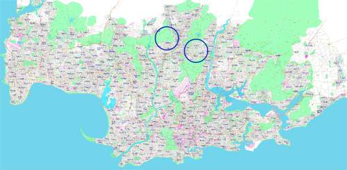
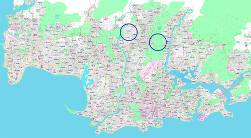
Let’s compare a before and after of the recent changes, with the different areas highlighted. First the before:
And the after: I think what these recent changes do is give the city a bit more of a realistic urban form. North of the core city (the area south of the airport, shall we say), a lot of the urban development follows 2-3 key valleys. Between the valleys would logically be hills, more difficult areas to develop and over time more likely to become parkland or a forest reserve. I think what the changes do is make the urban form fit more naturally with the likely natural form of the area.
What this leaves is a bit of a though in my mind around where other changes might be necessary in order to achieve this same result. Further to the west of the two blue circles is an area that doesn’t quite make sense yet – another strange east-west structure when the prevailing topography is clearly lending itself to an urban form characterised by north-south areas of urban development and open space.
I also have some remaining nagging feelings about both the fairly large harbour in the centre-left of the city (maybe it should just become a river) and the fact that where the city was founded seems a bit too far from the coast. The second issue is probably more difficult to solve, but something that might occupy my mind over the next while.
Hopefully it’s not quite so long until my next post. I seem to have worked out a way to print and scan “patches” to the city now that come out looking pretty good, which means things can advance a bit speedier than using the computer for everything.

Nice. Good to see a new post.
Ever thought about the area north and west of the circles being more of a plateau-like landspace, so it would be easier to develop?
And I am with you on the harbor, I think that more and more as I look at your map,, because I have always thought of cities on the coast with a harbor close to the CDB of a city, but that is not the case with LA (with Long Beach being the main harbor city in the area and not LA) and Houston, TX, but your city is a little bit more like Houston, IMO. If your city was more inland, you could pulloff having that large harbor and making those beach suburbs more like beach suburbs, like Galveston, TX, or you can take that little port area to the west of the city (West City and Glades Bay area) a little bigger and have more of an inland port and extend landin that open harbor area west (aka the Hong Kong Harbor Project… lol) and I think you can pull it off.