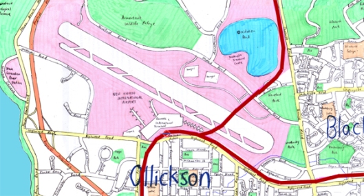
The Metro System – Line 3

Tags

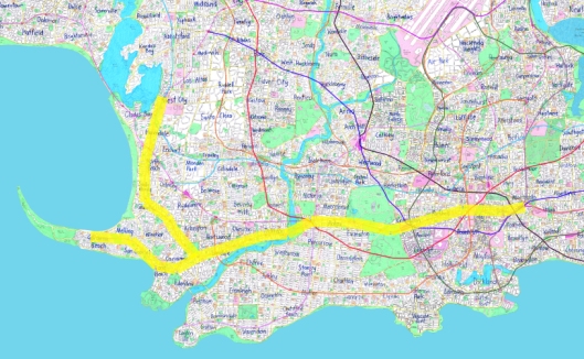
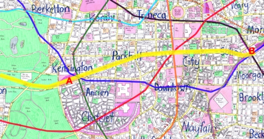
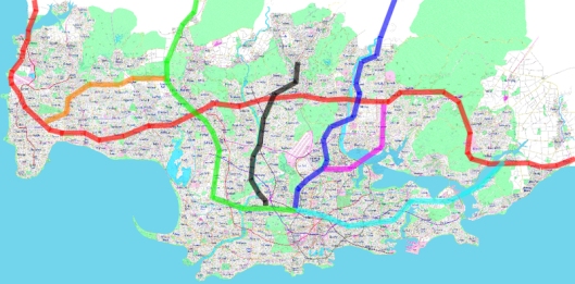
As I’m back posting on this blog, I thought I might as well continue working my way through detailing the city’s Metro system. Line 3, or the “Red Line”, is a really important route running in a general “U” shape east-west across the city. Let’s check it out generally:This line is perhaps more similar to “Line 1” than to “Line 2“, because it passes right through the central city and back out the other side. Once you think about it, there’s good reason to want a Metro line to do just that, as it means along the central section you’re picking up and dropping off a lot of passengers all the time – keeping the trains nice and full and busy in what was probably the most expensive part of the system to construct. With a line that terminates in the city centre, such as Line 2, it’s going to start losing passengers from its “peak load” level on the city fringe but won’t be as likely to be picking up passengers because they won’t have too many “destination” stations left on that line. So your central part of the line isn’t used as much as it might have been.
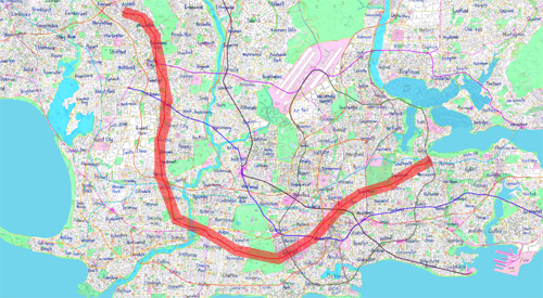
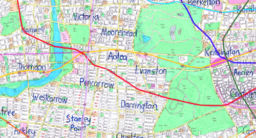
Starting in the northwest corner, let’s have a look in a bit more detail at what Line 3 is like.North City is a pretty major sub-regional centre, while areas north of it probably largely developed in the early part of the 20th century – to a reasonable density but probably mostly standalone houses with some terraced housing and perhaps some more recent low to medium rise buildings along the main roads. I’m guessing that it’s quite likely not all trains proceed past North City, with some likely to terminate or begin their runs there due to the lower demand further north. One thing that’s never quite felt right is where the line ends, perhaps that’s something I need to come back to in the future. Potentially I could pull the whole line back to North City with commuter rail handling further north (as otherwise we realistically need four-tracks with two for commuter trains and two for the metro trains, perhaps a bit unrealistic).
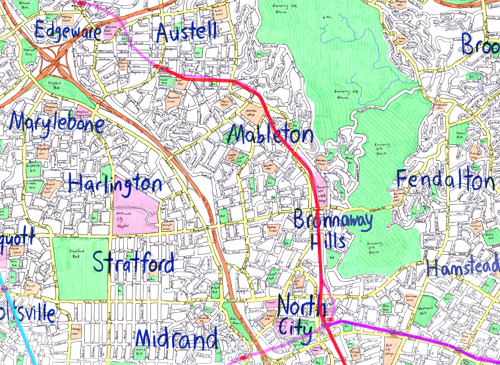
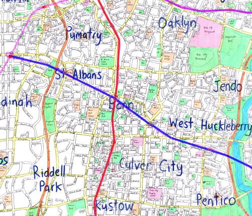
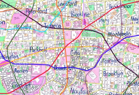
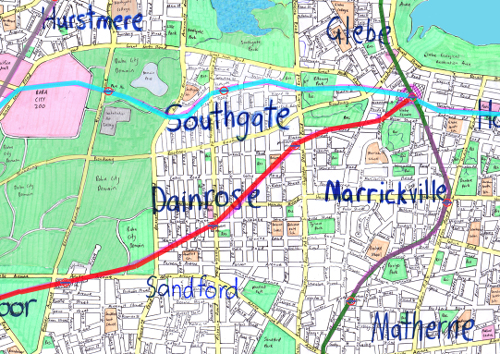
Shifting further south now, we come into the area the feels like the core patronage generator for this line – a series of pretty dense town centres focused around the metro line as well as some larger employment areas further to the west:Further south again is generally a similar story, with the inclusion of a really key interchange point with the Aqua Line (Line 5) probably used by a lot of people to transfer as Line 5 then serves a number of really important inner suburbs and cuts across the northern part of the city centre – also passing pretty close to the University. From this point the line turns to the east and heads towards the central city. The large area with a gridded street network was probably built in the late 19th century and could be similar to large tracts of Brooklyn in New York City (so pretty intense). The line then passes underneath the very oldest part of the city – from the Middle Ages, as it once again turns northwards on its way through the city centre. In this section there are a huge number of interchange with other lines, the Civic Station commuter rail terminus and obviously the massive employment concentration that’s in the city centre. The line cuts southwest to northeast across the central city, probably carrying a large number of shorter trips on this section as people travel around the very inner city:From here it’s not too far to where the line terminates – at a fairly major interchange station at Glebe. This eastern section is probably reasonably busy right through it – due to transfers from Glebe, but clearly not as busy as the central and inner-western parts of the line. I think generally it balances out reasonably well though:I think that perhaps after Line 1, this line could be one of the busiest on the network. I’m not entirely sure about whether it would have been one of the earlier or later lines built on the network, certainly not the earliest but at the same time it doesn’t feel like it would have been recently constructed – as there has clearly been a land-use response to it that has been happening for quite some time.
A logical urban structure

Tags

,

I found myself working on further updating the city over the weekend so thought it might be a good opportunity to post again on here – in particular around what I was actually doing with a couple of fairly significant changes to the structure of the city’s form.

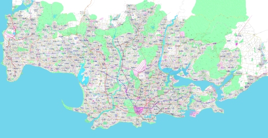
Let’s compare a before and after of the recent changes, with the different areas highlighted. First the before:

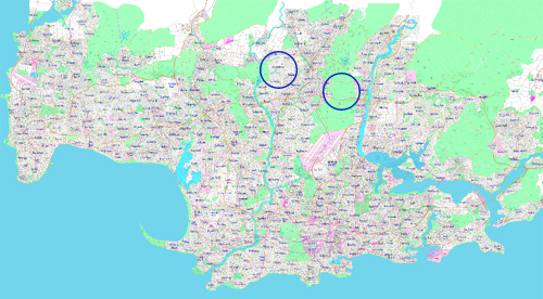
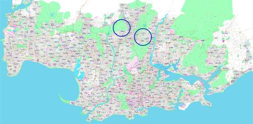
And the after:I think what these recent changes do is give the city a bit more of a realistic urban form. North of the core city (the area south of the airport, shall we say), a lot of the urban development follows 2-3 key valleys. Between the valleys would logically be hills, more difficult areas to develop and over time more likely to become parkland or a forest reserve. I think what the changes do is make the urban form fit more naturally with the likely natural form of the area.

What this leaves is a bit of a though in my mind around where other changes might be necessary in order to achieve this same result. Further to the west of the two blue circles is an area that doesn’t quite make sense yet – another strange east-west structure when the prevailing topography is clearly lending itself to an urban form characterised by north-south areas of urban development and open space.

I also have some remaining nagging feelings about both the fairly large harbour in the centre-left of the city (maybe it should just become a river) and the fact that where the city was founded seems a bit too far from the coast. The second issue is probably more difficult to solve, but something that might occupy my mind over the next while.

Hopefully it’s not quite so long until my next post. I seem to have worked out a way to print and scan “patches” to the city now that come out looking pretty good, which means things can advance a bit speedier than using the computer for everything.

Random Suburb: Maplewood

Tags

, ,

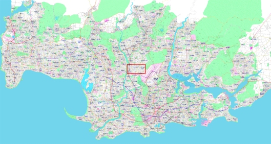
This is the first of a series of posts that will pretty much arise from me zooming in randomly on a part of Baba City and then exploring in a bit more detail what that part of the city might be like. Today, we focus on the area around a suburb called “Maplewood”. Here’s an overview of the area:

The first step of exploring what this place might be like is to get a general understanding about when it would have developed. My earlier post, which looked at the stages of urban development for Baba City, suggested that most of this area would have developed in the early part of the 20th century, except for a fairly thin sliver along the river in the far western part of the map above, which developed in the late 19th century, probably just preceding when the Metro Line went through.

As shown in the map below, this part of the city is fairly central:  

The area’s central location plus its early-20th century development date suggests potentially quite an interesting eclectic mix of building typologies – somewhere of an ‘in-between’ of larger-scale apartments, joined terraced houses and standalone detached housing. Some of the more outer parts of New York City’s “five boroughs” may give us some clues about what this place would be like – perhaps particularly around the area of “Flushing“, because it is in close proximity to La Guardia Airport just as this area is close to a large airport. Here’s what a part of Flushing looks like from above:

So quite a wide range of different housing types and quite a mix of uses too I’m guessing.

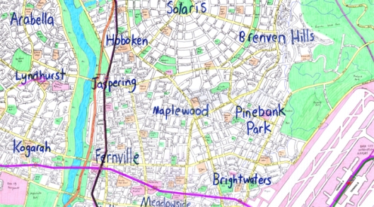
When thinking about what Maplewood and its surrounds would be like and what role it plays in the city, I find myself thinking a lot about its nearby suburbs. Obviously we have the Airport to the east, which is a major employment node (both itself and the surrounding business park) but would also be likely to act as something of a nuisance to residents and probably means this isn’t the most extremely rich part of town. At the same time not too far west we have a river, and despite a motorway running along one of its banks, it seems fairly likely that the river is seen as one of the city’s top amenities – with significant development along its banks to take advantage of views down to it and of recreational opportunities along the river.

Zooming out a bit (but not too much) we get a better understanding of this part of the city. 

The Black Metro Line (explained in more detail here) is the main transportation link with the rest of the city, along with the motorway which runs next to the river. The suburb of Solaris to the north is a major master-planned community of the 1920s, probably developed as an expression of the Garden City ideology while areas to the south are probably progressively more intense, with Brightwaters near the airport likely to be feeding off the airport as a bit of a business centre itself.  Fernville, Jaspering and Hoboken – major centres along the river – probably started life as separate towns but these days would probably contain quite a few high-rise apartment buildings in particular, due to the good access provided by the Metro line and the amenity of the river.

All up, I think this would be a reasonably interesting part of the city to life or work in. It would probably be a place that’s seen a lot of change over time and would continue to see change, as houses are turned into apartments, warehouses into offices and perhaps vice-versa. A little bit of everything might exist in this part of the city.

Monumental Sight-Lines

Tags

, , , , ,

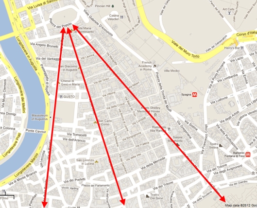
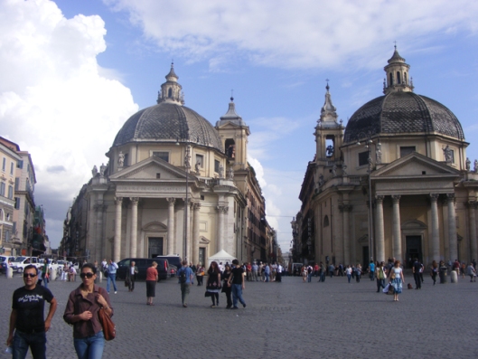
In a few cities around the world you see good examples of what I tend to call “monumental sight lines”. These are places where everything has been lined up to create a long viewshaft – typically leading to an important place. Some of these have been in place for a very long time, as Rome is full of such sight-lines. Perhaps most famously at the Piazza Del Popolo:

All the long streets converging on the one piazza creates some pretty amazing views:

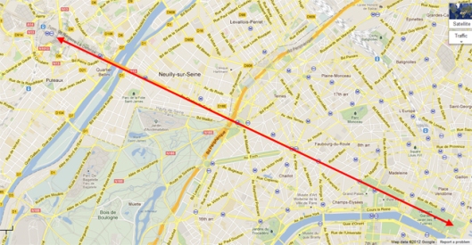
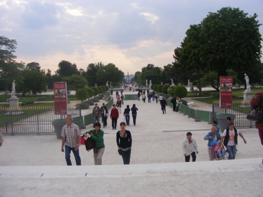
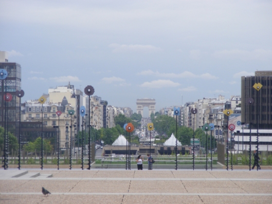
Another classic example of very long sight-lines is Paris – with an extremely long one between the Tuileries Gardens and La Defense. 

When I was in Paris I found myself quite obsessed with taking photos along this axis. From the very eastern end:

And the very western end:

It’s around 8 kilometres end to end along the line of the arrow drawn above. With the Arc de Triomphe roughly halfway along it.

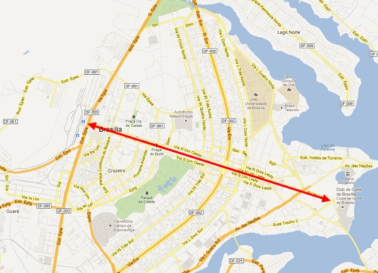
Many other cities have similar long viewshafts – Washington DC, Brasilia and Canberra are cities that immediately come to mind. The “Monumental Axis” of Brasilia is even longer than our Parisian viewshaft, really defining that rather strange city:

I’m probably generally quite fond of the long-distance views that city design techniques such as those listed above create. As a visitor, it certainly makes for some pretty dramatic photographs and it means you know where you’re going – even if the straightness of the journey perhaps highlights how far away you are from where you’re going.

But at the same time, for some of these views, there’s something a bit uncomfortably artificial about it all. You don’t get it so much in Rome and Paris, but elsewhere it can feel a little bit as though the cities have tried perhaps a little bit too hard to accommodate, celebrate and highlight the very long views that are creating through such techniques. Brasilia is probably the classic example of this – a city that barely manages to function because of its truly bizarre, Le Corbusier inspired modernist design. Washington DC struggled for centuries to properly get going, largely because of its layout. And even today the vast space used up by Washington Mall and the wide avenues further afield (not to mention the strict height limits) push employment out of downtown Washington to edge cities like Tysons Corner.

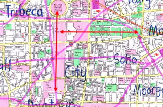
For Baba City, I have created what feels a little bit like a half-hearted attempt to create some longer viewshafts in parts of the city centre:

The north-south sight-line is around 2km long and the east-west one a bit shorter. Both focus on attention on what would be important buildings, while also providing a sense of space to the central city which is otherwise quite a maze of short little streets heading in all sorts of higgledy-piggledy angles. These probably would be quite dramatic spaces, depending of course on the details of the architecture of our museum, city hall and the national monument: all important public buildings that these spaces draw attention to.

But at the same time I also feel slightly uncomfortable at having such convenient viewshafts in a city that developed during an earlier time to when it seems these were really in fashion (although Paris and Rome show us they have been around for a very long time). Were huge chunks of the inner city demolished to create massively wide avenues for past rulers to parade their military might? Was it a 20th century phenomenon to create grand civic spaces, but in a way that never quite worked (like San Francisco’s civic centre)? I’m perhaps more comfortable with how the east-west sight-line works – through a park that’s broken up by a series of paths/narrow streets. If I was to redraw the area in the future, I would possible make the north-south one a little narrower.

Quality urban expansion

Tags

, , , ,

There are a million examples around the world of how to do urban expansion the wrong way: auto-dependent sprawl, cul-de-sacs, single-use development, leapfrog development, commercial strip development, giant carparks seemingly eating everything else… and so on. Most often the general feeling is that these situations have occurred through a lack of planning, but ironically they have tended to occur over the past 50 years when we have done more planning than ever before – and often it is the planning rules that inadvertently support and reinforce such poor urban outcomes.

Just looking at street patterns to give us a general indicator of what a place might be like, Baba City has a few areas that could be considered ‘auto-dependent sprawl’. Here’s an example:

The cul-de-sacs suggest an auto-focused street network, based around a traditional hierarchy of arterials, collector and local roads – with little effort put in to thinking about pedestrian connectivity (although that’s always possible by connecting the ends of cul-de-sacs, this tends to create alleyways that don’t feel particularly safe). On the plus side, the main road network is fairly legible and in a rough grid – suggesting that a logical bus network could exist. While the details of density, mix of uses, the quality of public transport provided and a myriad of other factors would determine whether this area feels like yet another soulless piece of sprawl or something more interesting and sustainable, we wouldn’t exactly think of here as best practice for how to do urban expansion.

As the by-line for this blog indicates, one of the purposes of these posts is to use the analysis of a fictional place – which frees us of preconceptions of the city we live in – to assist in developing our thinking about real places. So in a way that’s a bit removed from thinking about reality, how might that look? Particularly as it feels as though we haven’t done ‘best practice urban expansion’ (whatever that might be) for quite some time. There are some hints in the work done by New Urbanists, while the need to integrate with high quality public transport (being “on the way”) also sits high in my mind. Melding these ideas together with “Transit Oriented Development” seems like a general way forward – with specifics obviously tailored to each individual situation.
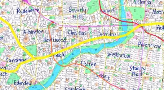
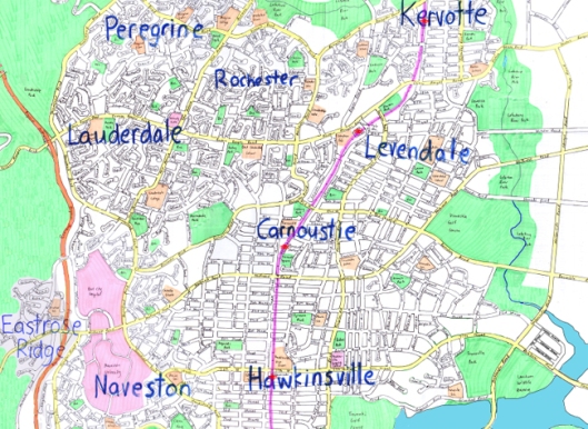
Interestingly, perhaps a part of Baba City which gives us some clues about how to do urban expansion well is located almost directly east of the suburbs shown in the map above. We need to zoom out a bit to fully encompass the area:

The rail corridor (the purple line) has been the focus for development, with the four main suburbs (Hawkinsville, Carnoustie, Levendale and Kervotte) being centred on train stations. Obviously there’s only so much that’s immediately obvious from a street map, but we have most of the streets that people would live on being at right angles to the railway line, meaning that all the streets kind of “feed into” either a railway station itself or into a street that will take them to a station. For those beyond walking distance, east-west arterial roads would carry feeder bus services, once again feeding people into the rail network for trips connecting them to the rest of the city. The contrast between the street layout of the area around the rail line with the more auto-dependent area in the northwest becomes quite starkly clear.

If I was to refine this area even further perhaps, I would probably be looking at way of having an even more connected street network, making the town centres a bit more obvious (and illustrating how density, mixed use and retail would be focused there) and ensuring that all the rail stations were at points where a major east-west arterial road crossed the tracks – to make transfers between bus and rail an easy and quick process. But overall, we can see that through basing our suburbs around train stations, having a legible grid to feed people to train stations and well placed arterial roads for feeder bus trips, we can end up with what’s probably still relatively low density suburbia being something other than your typical car-dependent urban sprawl.

The Metro System – Line 2

Tags

Line 2 of the Metro System serves much of the western part of the city, pretty much heading due west from “Central Station”, splitting in half towards its western end. Here’s a general look at the area of the city it serves:

In the central city, the line provides a key connection between two of the main commuter terminals: Kensington Station (A) and Central Station (B). It also connects with a large number of the other metro lines running through the city centre:

Further out to the west, the line passes through what would seem like fairly dense suburbs along the northern side of the river. You can imagine the line being put through in perhaps the early decades of the 20th century, facilitating the growth of these suburbs, then perhaps in more recent years a spread of employment along the line, perhaps a few high-rise residential buildings in close proximity to stations, taking advantage of the attractiveness of the area:

The more southern of the two branches heads off to serve a coastal residential community (probably similar to Bondi Beach in Sydney), while the more northern route hooks up with “West City”, a major employment hub for the western part of the city (the main connecting hub between the city centre and New Haven further to the west).

Compared to Line 1, Line 2 has different major patronage attractors along its route. There’s a university near its station in West City, there are major beaches that are likely to be flocked on sunny weekends, there’s a major museum not far west of the city centre and of course there are the two commuter rail terminals. That said, I don’t think it’s likely to have quite as high patronage as Line 1 – a commuter rail line would take most of the long-distance passengers from the west (although along a different catchment) while the far west sections of the line are probably not as high density as most of the areas Line 1 passes through. However, it’s still a key line in the Metro system and most probably a very busy one too.

An Evolving City

Tags

, ,

My previous post about the city’s motorway system highlighted an interesting question for me to consider: whether I had “over-provided” the city with infrastructure generally. Obviously, when drawing “fantasy cities” it’s easy to be idealistic about how that place should be – what the best subway system would look like, what the best motorway system would look like, how the best urban design would occur and so forth. While that’s probably fine to an extent (after all, it seems a bit pointless to design a horrific city, they exist too common in real life), it’s also unrealistic and perhaps a bit boring. No city is a finished product, every city evolves, every city has plans for infrastructure projects that they can’t afford yet or simply aren’t necessary yet. There are always gaps in networks, pinch-points, incomplete roads and so forth – in fact it’s arguably these flaws which make a city so obviously real, so obviously evolving.

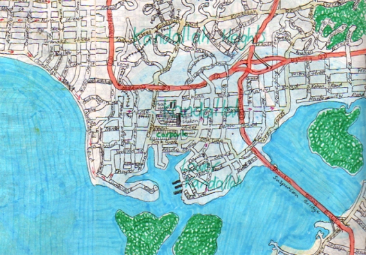
Somewhat unsurprisingly, I have drawn and redrawn some sections of the city on many many occasions. Not only are there the originals, scanned out of the exercise book I put together 15 or so years ago when I first drew this city, but also over the past few years there have been the areas that I have updated almost obsessively. The goal has often been to make these places better and better, often for completely justifiable reasons such as fixing stupidly obvious flaws that would never happen in real life. A good example is shown in the map below, where my carelessness at joining maps together across separated pages of an exercise book led to a pile of pointless dead-end roads:My next crack at this area, when I redrew it in more recent times, changed things around a fair bit while trying to still keep some of the “essence” of what I had originally drawn. This is how it was until just the other day, when after writing my motorways post I questioned whether the motorway which passes through this area is really necessary after all:

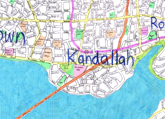
The whole impact of the motorway, and even the train line, on this area seems quite stupidly horrific, and if the motorway isn’t actually necessary then perhaps we can improve things quite a lot – so I had quite a mess with the area:

There are probably a few more final details to add, but generally the suburb of Kandallah (name influenced by my first trip to Wellington back in May 1993, which gives me a good hint of when I first drew the city) seems a much nicer place without the giant overhead motorway barrelling through it.

What’s perhaps more interesting though is the philosophical question that arises in my mind as I significantly change areas in ways that simply wouldn’t happen in real life. Did the previous version of this area just not ever exist? What about some changes where I’m obviously putting in a thing that’s a clear addition – is it reasonable to think that my process of drawing the city is somewhat akin to a reality of the place growing over time? But in some cases it certainly isn’t, because I’m changing the coastline, ripping out huge pieces of infrastructure, changing an entire street network or whatever. It always feels a bit uncomfortable to make these changes, like I’m rewriting history: no, actually that didn’t happen, this is what happened.

Maybe in an ideal world I will one day clearly “finish” the city, and then the changes I make to it from then on will somewhat approximate reality of how that city would grow and change over time. But I think in reality that’s unlikely to happen – especially now as I share the city with the world I will get more and more ideas about how it should be different: not necessarily better, but more realistic and perhaps more interesting. While that somewhat disturbs my idea of the city being a place, and is perhaps not my ideal way of figuring out how cities evolve over time, it is still an evolution of the place.
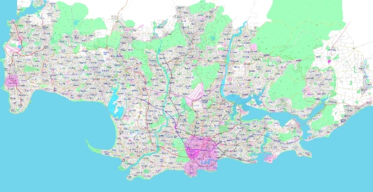
That said, I think that I do want to do a better job of making the city a bit more real. As painful as the process will be, I figure that some of the Metro Lines should perhaps be “proposed” lines, maybe some extensions should be “under construction”. Some of the motorway network should be incomplete, with plans for an upgrade but not yet affordable, or perhaps not necessary due to good alternatives existing. Some areas highlighted for redevelopment might need to be shown, in one way or another. In a sense, these issues remind us of the unfinished nature of a city, that it’s a process as well as a product, that it’s evolving. And this is great, because it’s what makes cities interesting.

The Motorway System

Tags

,

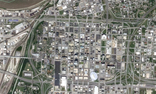
I have mixed feelings about motorways. On the one hand, over-investment in motorways at the expense of other transportation modes has destroyed the heart and character of countless neighbourhoods and cities over the past few decades. Take a look at an aerial photograph of Kansas City for example: The impact of the Cross-Bronx Expressway, widely blamed for sending the Bronx into urban decay, is also well worth keeping in mind.

At the same time though, motorways clearly have their advantages. They enable long-distance trips efficiently around a city, especially for the movement of freight or for other types of trips where public transport isn’t particularly viable. Furthermore, they also take pressure off local roads, freeing them up for shorter trips, passenger transport and also ensuring they’re nicer places to live, work, shop etc.

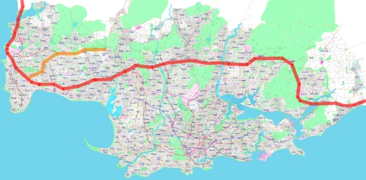
Our city contains what I think is a reasonable, but not excessive, number of motorways. It’s interesting to look at how they fit together into a system. The main cross-city motorway is shown in red in the map below, known as “Regional Motorway”:

Thinking about how this city fits into the entire country, regional motorway plays a key inter-city role – joining together many of the cities, although I’m not sure whether its volumes will always justify motorway standard.

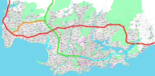
Working west-to-east, the “Western Expressway” is shown in orange in the map below. It supports the city’s major development area throughout the 1950s and 1960s, linking into other motorways at both ends:

At its eastern end, the Western Expressway links in with the “Baba City – Emerald City Motorway”. Clearly, given its name, this motorway links our city with one that’s fairly nearby (say around 150km to the northwest, although inland a bit). At its southern end, this motorway delves close to the heart of the city before turning into another motorway.

While drawing the city, I had probably expected this motorway to be perhaps the busiest – at it serves a pretty major section of the city, quite a lot of industrial/commercial area (the corridor to the south of its interchange with Regional Motorway) as well as obviously linking through to a major motorway heading out east. This motorway, called “Pacific Coast Motorway” (perhaps giving us a clue about where the city would be located?) does a fairly similar job, but in the eastern part of the city:

Our next motorway heads north from a point along the “Baba City to Emerald City Motorway”, it’s called the “Northwest Motorway”:

The next major “north-south” motorway is (somewhat unsurprisingly) called the “Northern Motorway”. It follows one of the major development corridors heading north out of the city:

The last major motorway (Baba City Motorway) is perhaps the shortest of the lot (except for a small link connecting to the airport) and cuts across one of the other main development zones of the city in the post-war era: The final little bit of motorway, as I said, links to the airport – meaning that the complete network is shown in the map below:

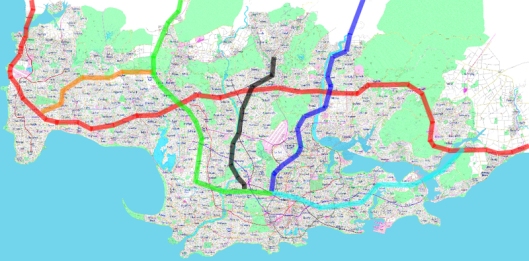
A few thoughts stand out when looking at the complete network:

  • The network is perhaps a little bit too conveniently complete. This fits with a few thoughts I’ve had about the city in general, that may it’s a little bit too ideal, too complete, too much money has gone into infrastructure to be realistic.
  • There’s a pretty large chunk of the southern part of the city without any motorway access. This fits fairly well with that being one of the oldest areas.
  • Maybe the purple motorway (Baba City motorway) in the map above isn’t actually necessary…?

I do think that in general I perhaps need to take a more realistic approach to the completeness of the city’s infrastructure, or perhaps need to think about ways of highlighting the city as being bigger than I had perhaps previously thought – population wise – to support such a high level of infrastructure provision.

Phases of urban development

Tags

, , , , ,

Something I’ve always found quite interesting is to look at the phases of development a city has had. How big was the city in 1900? Where developed prior to the First World War? How about between the wars? Why did development occur in those places first rather than elsewhere? How do the street patterns, building type and general feel of an area reflect the times it was built in?

Exploring this process of urban development through analysing the city is an interesting process. I’ve already talked about the oldest part, which probably dates from the 1600s, or perhaps even earlier. So that forms phase one of our city’s development, perhaps generally where things were at in around 1750 – so still a fairly small place, although pretty intensively built up.

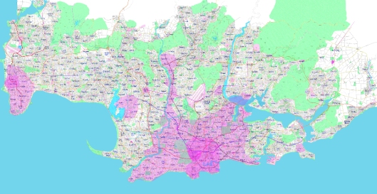
The first phase of development is the purple area in the picture above.

By say 1850, railways and the industrial revolution has really started to change our urban places. Typically the need for walls had stopped, plus cities were struggling to fit within those boundaries anyway. Here we also see the earliest stages of New Haven developing in the west, highlighting that its urban core also dates from a pretty early date. Our main area has grown fairly considerably and would have perhaps had a population pushing 250,000 – all pretty tightly packed in as most people needed to live within walking distance of where they worked. We also see the use of the port becoming increasingly important:

The third stage is where the city would have reached at 1900. This is a fairly arbitrary cut off date in a sense, but shows us that the second half of the 19th century continued to be a time of really rapid urban growth. This pre-1900 area forms a pretty distinctive “core” to the current metropolitan area, we see development following the rivers (for transport purposes and perhaps because industry wanted to be there too) and also following where some of the metro lines are today, telling us that these lines were probably some of the earliest, precipitating urban development around them:

The fourth phase, which is where the city would have been by the time of the Second World War, indicates a further level of quite extensive development during the first half of the 20th century. Some master-planned communities would have followed urban trends at the time, like the Garden City movement. This is perhaps most obvious in the suburb of Solaris, which I will dedicate a post to in the future. Development has also taken place along the harbour, as perhaps the rise of the automobile meant that people were no longer strongly required to live near a train station or tram line to get to work, although the extensive Metro network the city had at this point probably meant lower than average car ownership rates (sort of like New York in the USA). Population is likely to have hit a million in the early years of the 20th century, and perhaps has reached 1.5 million by World War II – indicating slower growth since that time (remembering that the current population is around 2.7 million).Obviously everywhere not shaded has developed since the Second World War. The really large chunk in the west probably was built in the 1950s and 1960s, perhaps with significant government intervention to boost housing stocks after the war. In more recent times, development has stretched up some of the valleys, but has also probably been largely through intensification as the area’s geography makes further expansion very difficult (except for in the far northeast, which is just getting a bit too isolated).

Compared to a lot of cities, this one certainly grew a lot in the 1850-1950 period, perhaps reflecting my desire to have a city that is shaped by urban trends during this time. I suppose as a matter of practicality too, with such an extensive Metro rail system, I need an urban core that’s very dense and also quite large – which realistically requires a lot of development to have occurred during the 1850-1950 period.
Airports

Tags

,

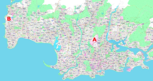
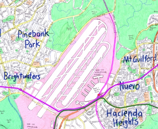
The city has two airports, which reflects the fact that it’s really two cities that have joined – one much larger and one to the west (New Haven) that has grown over time and eventually merged in with the main urban area. There are probably additional minor airports/military bases/aviation fields, but those are yet to be drawn (which is perhaps a good reminder for me to think about where they might go). The map below shows the location of the two airports (A being the main one, B being the secondary one):The main airport (Baba City International Airport) is actually fairly central, located approximately 9 kilometres north, and slightly east, of the city centre. Here’s what it looks like rather more “zoomed in”:

There are three runways, although perhaps one of them might be largely set aside as an emergency backup runway. I’m not entirely sure of how far apart runways need to be in order to operate simultaneously, but my expectation is that the centre runway would be the backup, leaving the other two to operate in normal situations – the shorter one handling shorter-haul flights and the longer one carrying the big planes. There’s just the one terminal (it seems that splitting domestic and international terminals is more trouble than it’s worth) and hopefully quite a lot of room for ancillary aviation activities (these occur further to the south too, which is a quite major industrial park).

Transport to the Airport is fairly comprehensive. The orange line at the bottom of the picture indicates a motorway (a fairly short stub motorway that links to one of the city’s main north-south motorways). The purple line travelling east-west is one of the city’s Metro lines, the green line is another metro line, while the pinkish line travelling in a north-south direction is one of the main commuter rail lines – probably with at least four tracks – and provides a high-speed service between the airport and the city centre (kind of like the Heathrow Express).

The second airport (New Haven Airport) also provides for international flights, but I expect to a much more limited number of destinations. It is possible that the airport is used by discount airlines, as it might have a bit more spare capacity than the city’s main airport and therefore offer cheaper landing fees.

There’s just the one runway, a combined international and domestic terminal, and once again access to a Metro Line (the maroon coloured line, which splits into two just north of the airport station).

Airports are important ‘gateways’ to our cities, typically providing the first impression someone has of that country. Making comparisons between say, Singapore Changi Airport and LAX Airport in Los Angeles can’t help but begin to form your impressions of those places: Singapore as incredibly organised, cutting edge, willing to invest in public facilities. Los Angeles as, well, not quite the same. While Airports have never fascinated me in the same way as, say, railway stations and metro networks, there’s certainly value in them and I did work pretty hard to ensure that the city’s main airport in particular came across as a world-class airport befitting a city of its size.